
The Storms We Don’t Talk About Are Getting Stronger
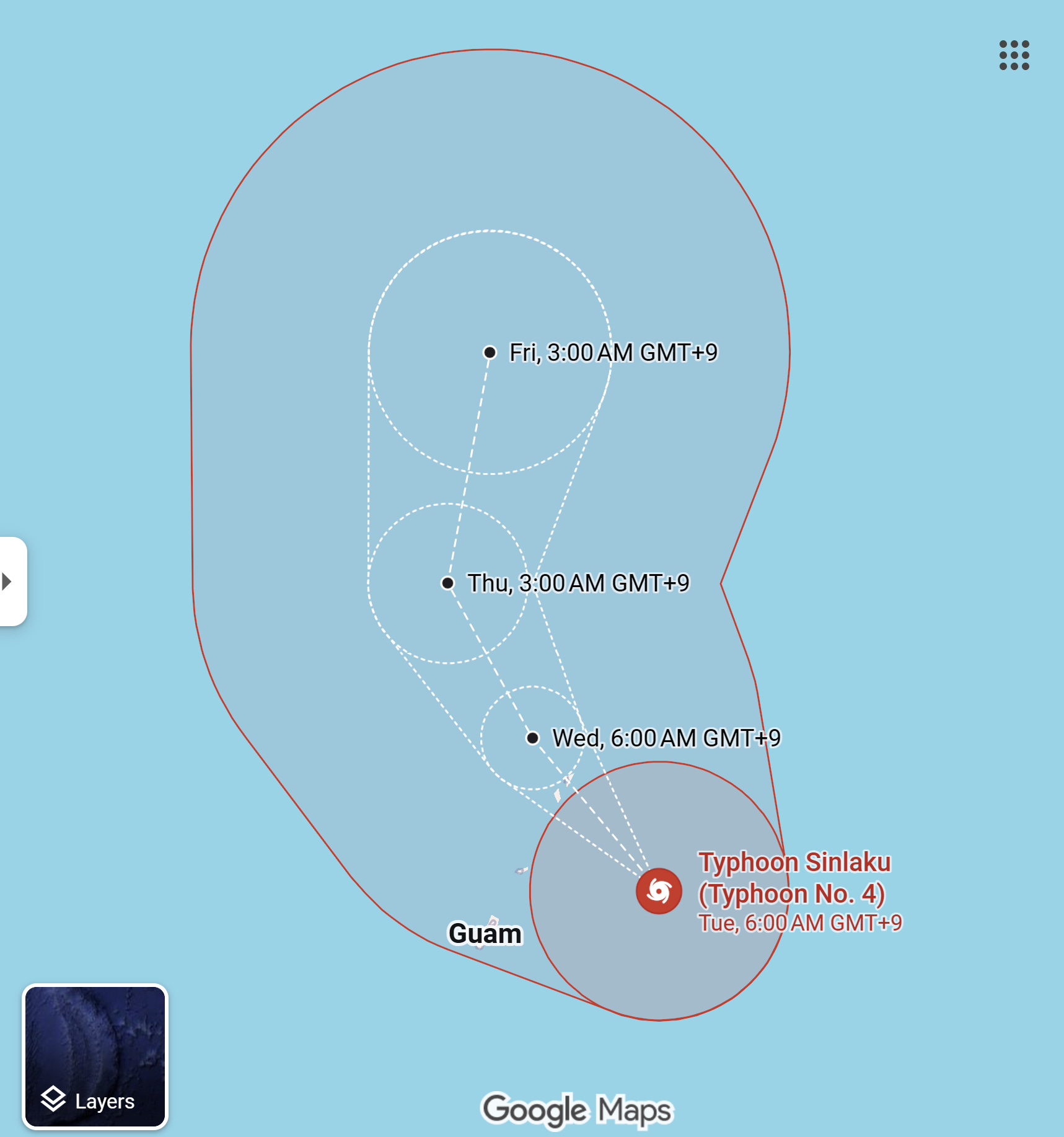
Super Typhoon Sinlaku moving toward Guam and the Northern Mariana Islands

Storms like Super Typhoon Sinlaku are getting stronger. Coverage isn’t. I do this work independently, without institutional backing. If you value clear, data-driven reporting on climate and risk, consider supporting it with a subscription.
We have a tendency in the United States to ignore hurricane season in the Pacific and Indian Oceans, to treat them as distant systems unfolding somewhere beyond the edges of our maps and our concern.
The Atlantic dominates the conversation — its storms named, tracked, anticipated in real time by a public conditioned to watch the Gulf and the eastern seaboard.
But for U.S. citizens living in Guam and the Northern Mariana Islands, the Western Pacific Basin is not a distant theater. It is home, and it is becoming more volatile in ways that are increasingly difficult to ignore.
Super Typhoon Sinlaku, now at Category 5 strength on the Saffir-Simpson scale, is the latest reminder. Strengthened by an intense El Nino cycle, Sinlaku arrives not just with destructive force, but at a moment that unsettles the assumptions we still use to define these storms.
Hurricane season in the Western Pacific Basin does not officially begin until May 15.
That date, like so many of the boundaries we draw around natural systems, has always been a human construct, an attempt to impose order on something inherently fluid.
But the ocean does not recognize calendars, and increasingly, neither do the storms that form above it.
For a system of this size and intensity to develop a full month before the traditional start of the season is not just an anomaly worth noting; it is part of a broader pattern that suggests the season itself is stretching, loosening from the temporal constraints we once relied on.
This is not without precedent.
Research has shown that tropical cyclone activity in the Western North Pacific is becoming less confined to historical seasonal windows, as warmer sea surface temperatures persist longer throughout the year, quietly extending the period during which storms can form and intensify.
And yet, even as the risk evolves, the way we monitor and communicate that risk remains fragmented.
The National Hurricane Center, the institution most Americans associate with hurricane tracking, does not monitor the Western Pacific or provide that data or its associated visuals as part of its public-facing resources.
That responsibility falls instead to the Joint Typhoon Warning Center and a network of international agencies, a division of labor that makes sense within the architecture of federal bureaucracy but creates a quieter, less visible threat landscape for those outside the basin.
For the Americans living in Guam and the Northern Mariana Islands, the distinction is immaterial.
A Category 5 storm does not become less dangerous because it is tracked by a different agency. But the way that storm is communicated, how prominently it features in national discourse, and how urgently it is treated, can shape the speed and scale of response in ways that matter.
The region has already seen what this new reality looks like.
In 2023, Typhoon Mawar formed in the first week of the season and struck Guam as a Category 4-equivalent storm, leaving behind widespread damage and exposing vulnerabilities that had not yet been fully addressed when the next season began to take shape.
Mawar was not an outlier so much as an early signal, one of many that, taken together, begin to outline a larger shift.
Across the Western North Pacific, the science has been moving in a consistent direction.
Assessments from the Intergovernmental Panel on Climate Change and the World Meteorological Organization, along with a growing body of peer-reviewed research, point to a basin where the most intense storms are becoming more common, where rapid intensification events are occurring with greater frequency, and where rainfall rates are increasing as a warmer atmosphere holds more moisture.
At the same time, storm tracks are shifting poleward, bringing risk to regions that historically existed just outside the most dangerous corridors.
The Western Pacific is particularly sensitive to these changes, in part because it is already the warmest tropical ocean basin on Earth.
Here, small increases in temperature can have outsized effects.
Warmer water provides more energy for storms, while a warmer atmosphere amplifies their ability to produce extreme rainfall.
Beneath the surface, ocean heat content has increased significantly, allowing storms to maintain their strength even as they churn the upper layers of the ocean, thus removing one of the natural checks that once limited their intensity.
The result is a system in which storms are not only stronger, but capable of intensifying more rapidly and sustaining that intensity for longer periods of time.
For Guam and the Northern Mariana Islands, these changes are not abstract projections. They are immediate constraints on how people live and prepare.
Officials are now advising residents to shelter in place as Sinlaku approaches, a familiar directive in a region where evacuation options are limited by geography and infrastructure must repeatedly absorb the impact of high-intensity storms.
Each event compounds the last, testing supply chains, straining recovery systems, and narrowing the window in which communities can rebuild before the next storm arrives.
What emerges from all of this is not just a story about a single typhoon, but about a growing mismatch between the systems we use to understand these storms and the reality in which they now exist.
Our definitions of hurricane season, our monitoring frameworks, even our national attention remain anchored to an earlier climate —one in which the boundaries were more stable, the signals easier to interpret.
Super Typhoon Sinlaku does not fit neatly within those boundaries.
And neither, increasingly, does the basin it comes from.
The question is not simply whether we are prepared for this storm, but whether we are prepared to recognize what it represents: a Western Pacific that demands the same urgency, the same visibility, and the same investment we have long reserved for the Atlantic.
Because for the millions of people living in its path, including American citizens, the consequences of overlooking that basin are no longer hypothetical. They are already unfolding, storm by storm, season by season, in ways that are becoming harder to dismiss as anything but the new baseline.
These stories don’t get the attention they deserve until disaster forces it. I cover them before that happens. If you value that kind of reporting, support it by becoming a paid subscriber.