

Dear Readers:
Some of the most meaningful work of my career has been alongside Indigenous communities fighting to preserve their lands, histories, and ways of life. Those experiences profoundly shaped how I understand geography, science, and our responsibility to the people whose stories have too often been erased.
This Indigenous Peoples’ Day, I’m sharing the extraordinary work of artists and cartographers who are reclaiming those stories, one map at a time.
Mesoscale News exists to tell the stories that deserve more attention, especially when they challenge the powerful, confront uncomfortable histories, or give voice to communities too often ignored. If you believe in journalism grounded in science, guided by compassion, and unafraid to speak truth to power, please consider becoming a paid subscriber. Your support makes this work possible.
On Indigenous Peoples’ Day, the artists and geographers restoring the histories that colonization erased, and why the fight to map Indigenous homelands is inseparable from the global struggle for land, identity, and survival.
Years ago, deep in the disappearing wetlands of coastal Louisiana, I stood alongside Indigenous tribal leaders searching for places that, according to the maps, did not exist.
Burial grounds. Ancestral settlements. Sacred places. Landscapes that had carried generations of history, only to be omitted from the official geographic record.
I was working with the Pointe-au-Chien Indian Tribe and the Isle de Jean Charles, documenting historical sites and studying how hurricanes, rising seas, and centuries of environmental change had reshaped their homelands.
My research in Louisiana eventually became my Ph.D. work, examining how Indigenous settlement patterns, burial practices, and oral histories could preserve evidence of catastrophic weather events long before modern meteorological records existed.
What began as an exercise in geographic science became something far more profound.
The absence of a place from a map does not mean it was never there. Sometimes it means the people who knew it were never asked. Sometimes the records were destroyed, the names changed, or the knowledge passed between generations in ways Western institutions never learned to recognize.
And sometimes, the people making the maps had every reason to pretend the land was empty.
The communities I worked with were fighting to preserve far more than their physical homes. They were trying to protect the places where their ancestors were buried, where their histories were written into the landscape, and where generations had learned to live with the water rather than against it.
But the water was rising. The marshes were disappearing. And many of those places had never been formally documented.
What happens when a people lose their land before the rest of the world has even acknowledged their history on it?
That question has stayed with me throughout my career.
And this Indigenous Peoples’ Day, I want to introduce you to some extraordinary artists, cartographers, and geographers whose work confronts that question from a different direction.
They are restoring Indigenous names to rivers and mountains. Reconstructing the geographies of nations that existed long before the United States and Canada. Transforming maps into works of art that challenge centuries of dispossession.
Their work is beautiful. It is scientifically and historically important. And it is part of a much larger struggle over who gets to define a place, who belongs to it, and who has the right to decide its future.
Before the Borders, There Were Nations
For thousands of years before European colonization, North America was home to hundreds of distinct Indigenous nations, with their own languages, political systems, agricultural traditions, trade networks, spiritual geographies, and relationships to the land.
The continent was neither empty nor waiting to be discovered.
Yet colonial maps frequently portrayed Indigenous homelands as territories available for occupation, acquisition, and exploitation. Native place names were replaced. Communities were omitted or displaced. Political boundaries were imposed without the consent of the people who lived there.
Maps became instruments of administration, property ownership, military expansion, and colonial authority.
The consequences extend far beyond the historical record.
A map that fails to recognize an Indigenous nation’s relationship to its homeland can shape decisions about land ownership, resource extraction, conservation, infrastructure, and displacement.
And the people whose history has been erased from the map may then be forced to prove that history existed at all.
Marlena Myles: A Homeland Written in Dakota
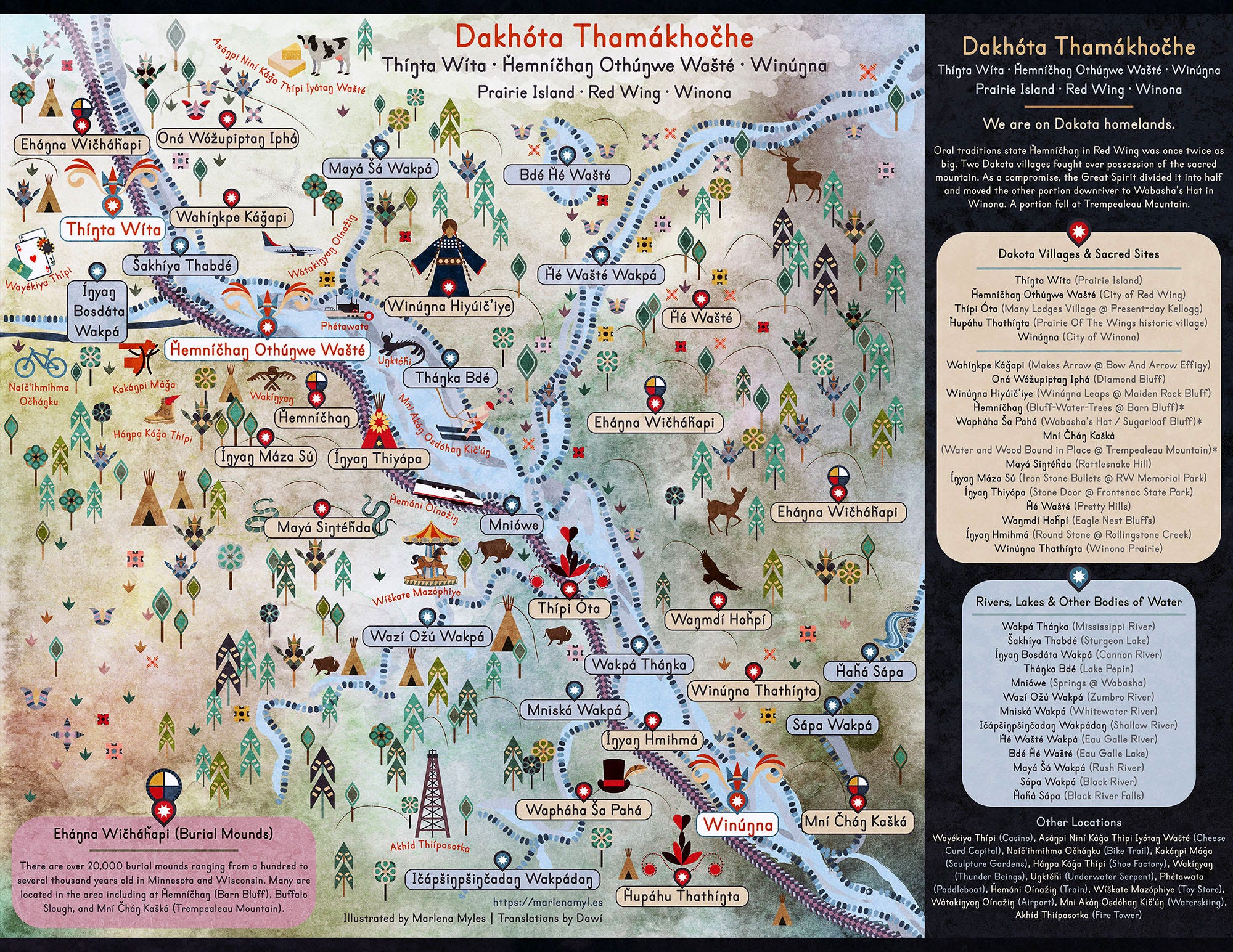
Explore Marlena Myles’ Dakota Land Maps
Artist Marlena Myles creates richly illustrated maps that restore Dakota names, stories, and cultural knowledge to the landscapes of Minnesota.
Her Dakota Land Maps, developed with Dakota-language contributions from Dawí, reveal a geography far older than the cities and state boundaries imposed upon it. Rivers, trails, and sacred places emerge through Indigenous language and memory.
These are more than historical reconstructions. They’re living expressions of Dakota identity, reminding us that Indigenous peoples are not relics of the past. Their histories, languages, and relationships to the land endure.
Margaret Wickens Pearce: The Stories Hidden in Place Names
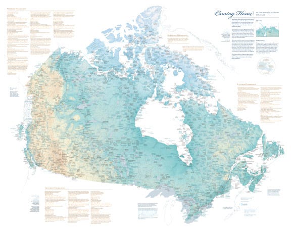
Explore Coming Home to Indigenous Place Names in Canada
Cartographer Margaret Wickens Pearce restores Indigenous geography by returning its original names and stories to the map.
Her Coming Home to Indigenous Place Names in Canada, created with Indigenous contributors, reveals how colonial naming practices obscured generations of cultural and ecological knowledge.
A place name can preserve the memory of a migration, describe a river’s behavior, or identify resources that sustained communities for centuries. Pearce’s work reminds us that changing a name can obscure far more than a location. It can obscure an entire way of understanding the world.
Aaron Carapella: A Continent of Nations
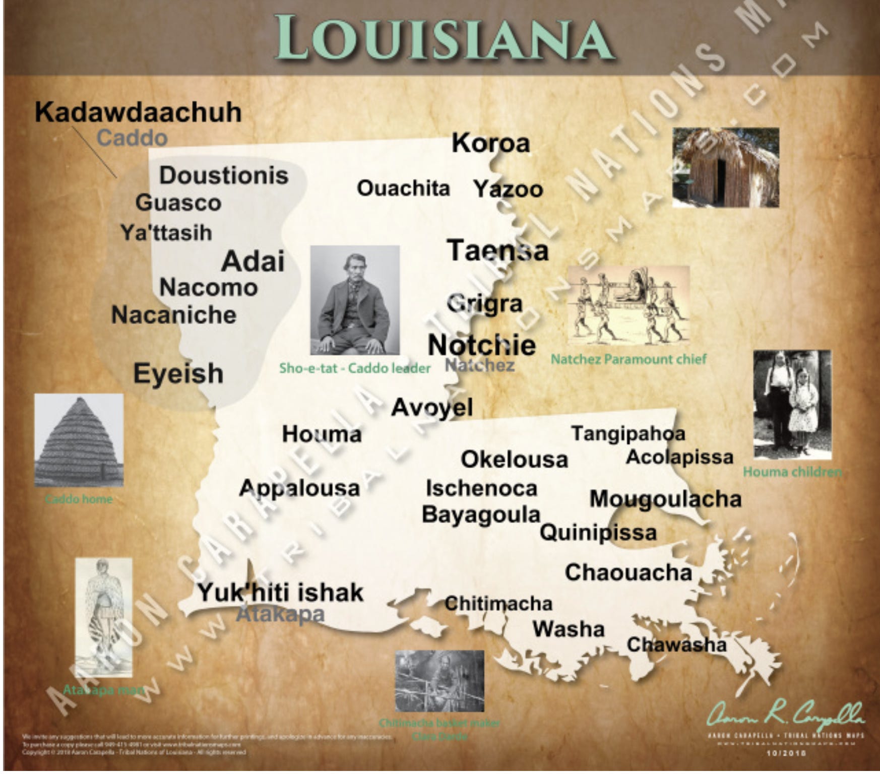
Aaron Carapella’s Tribal Nations Maps replaces the familiar political geography of North America with the names and homelands of hundreds of Indigenous nations.
Drawing on historical research, his maps challenge the notion that the continent was an empty wilderness awaiting European settlement.
No single map can perfectly reconstruct centuries of shifting territories and overlapping relationships to land. But Carapella’s work makes something unmistakable: long before the United States and Canada existed, this continent was already home to complex societies, political systems, and thriving nations.
Jaune Quick-to-See Smith: A Map of What Was Taken
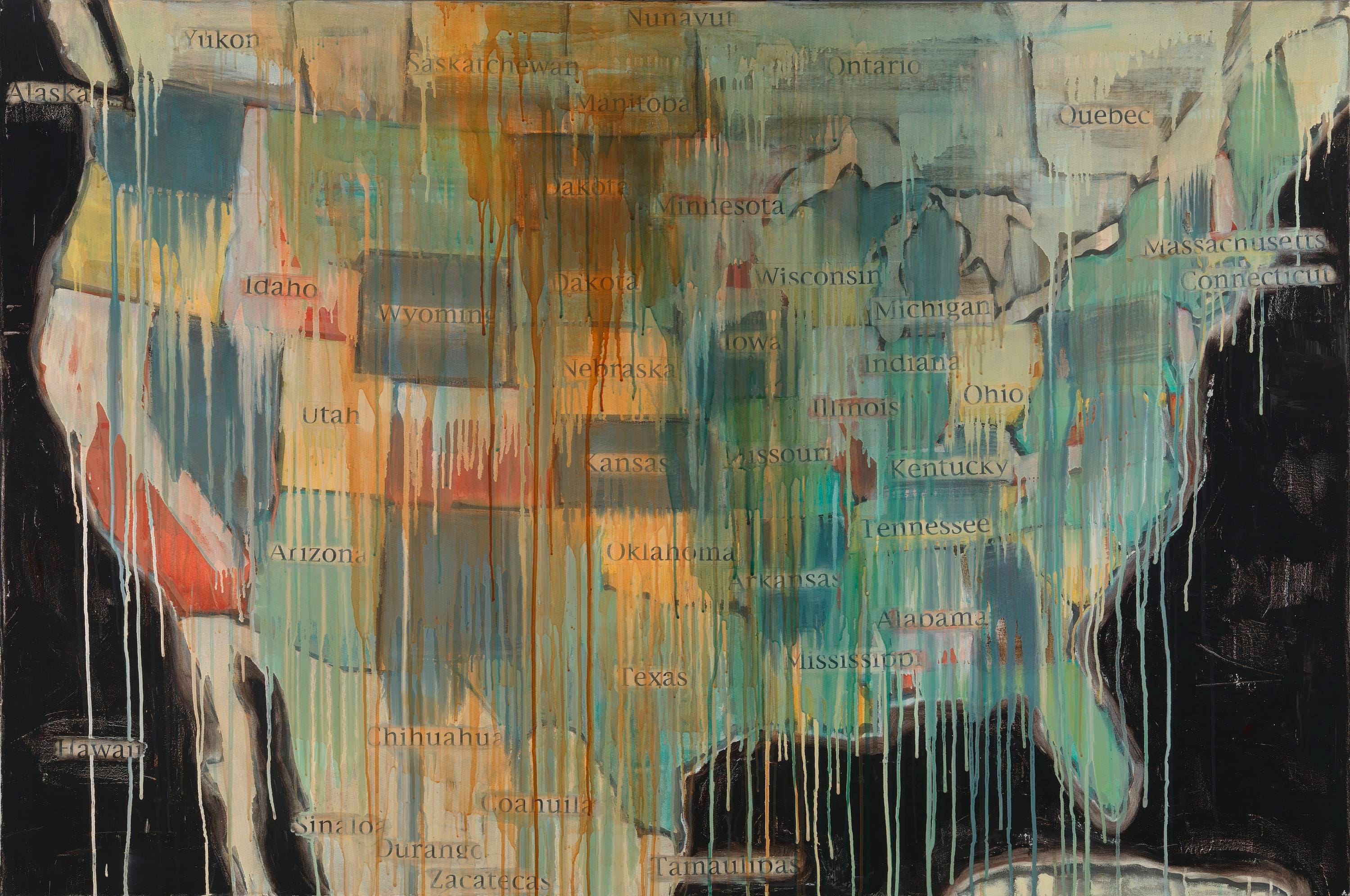
Explore Smith’s work at the National Gallery of Art
Artist Jaune Quick-to-See Smith transformed familiar American maps into powerful examinations of Indigenous dispossession and cultural erasure.
In State Names (2000), she removed state names without Indigenous linguistic origins, exposing how colonial geography has obscured the continent’s earlier histories.
Her work asks us to reconsider the authority of the borders and names we take for granted—and whose stories were displaced to make them appear permanent
Christi Belcourt: Painting the Geography That Maps Leave Out
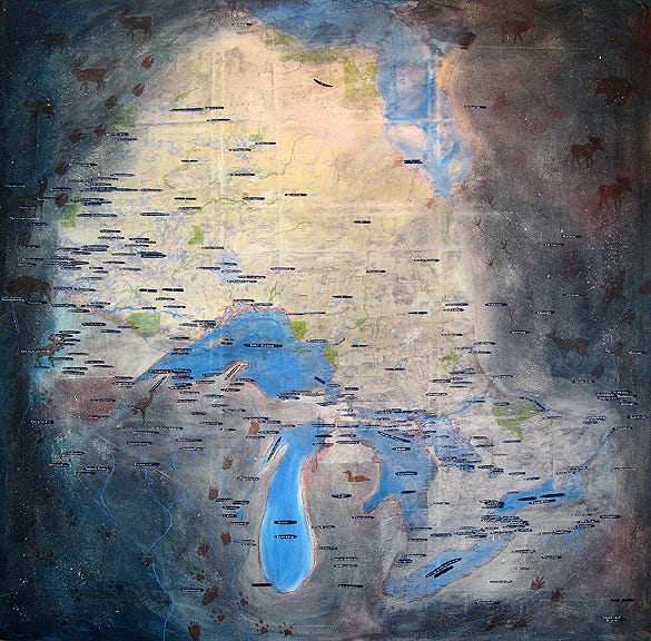
Explore Christi Belcourt’s work
Métis artist Christi Belcourt explores the relationships between Indigenous identity, land, and ecological knowledge through richly detailed paintings.
Her Mapping Roots: Perspectives of Land & Water in Ontario series combines contemporary maps with Indigenous place names and cultural imagery, revealing relationships to the landscape that conventional cartography rarely captures.
Belcourt’s work reminds us that land is more than property or a collection of resources. It is memory, culture, identity, and an inheritance that cannot simply be relocated or replaced.
Mapping as a Human Right
The struggle to restore Indigenous geography is not confined to North America.
Across the world, Indigenous peoples are using maps to defend their homelands against deforestation, mining, oil development, displacement, and the accelerating consequences of climate change.
In the Amazon, community-led mapping initiatives have documented ancestral territories, traditional resource use, sacred places, and environmental damage.
These maps can help communities establish evidence of customary land use, organize territorial management, and defend their rights in legal and political proceedings.
The Amazon Conservation Team works with Indigenous communities on participatory mapping and biocultural conservation.
Brazil’s New Social Mapping in the Amazon initiative has supported communities in producing their own maps, using GPS and locally defined geographic knowledge to document land use and strengthen territorial protections.
In the Peruvian Amazon, community mapping has similarly helped document Indigenous relationships with forests and waterways while supporting efforts to defend traditional territories.
The parallels with coastal Louisiana are unmistakable.
Indigenous peoples are frequently expected to demonstrate their historical relationship to lands that their ancestors occupied long before modern property systems existed.
Their oral histories, ecological knowledge, and cultural practices may contain precisely the evidence needed to establish those relationships.
But those forms of knowledge have not always been afforded the same authority as written colonial records, government surveys, or property deeds.
This creates a devastating contradiction: communities can be required to prove their connection to their own homelands using systems of documentation developed by the governments that dispossessed them.
Mapping can help challenge that imbalance.
But there is another danger.
When Indigenous communities document sacred sites, burial grounds, culturally sensitive landscapes, or valuable ecological resources, making that information public can expose those places to exploitation, vandalism, or further dispossession.
The goal cannot simply be to put everything on a map.
It must be to give Indigenous peoples authority over what is mapped, how that knowledge is used, and who is allowed to see it.
That is the difference between mapping Indigenous lands and supporting Indigenous sovereignty.
Working with Palestinians in the West Bank parallels much of my work in Louisiana: Generations beyond memory of people working a land being stolen from them, not because of hurricanes and climate change, but through administrative processes, being led by a foreign terror campaign, funded by the United States.
The Arctic: When the Maps Can No Longer Keep Up
Thousands of miles north of Louisiana, Inuit communities are confronting another consequence of a rapidly changing climate: the sea ice is changing.
Routes used for generations are becoming less predictable. Seasonal patterns are shifting. Knowledge of currents, winds, wildlife, and ice conditions is increasingly important for understanding both the changes underway and their consequences for Arctic communities.
Inuit knowledge systems contain extraordinarily detailed understandings of these environments.
Through projects such as SIKU and the Inuinnait Knowledge Atlases, Indigenous communities and collaborators are bringing traditional knowledge into digital mapping platforms.
These projects document travel routes, geographic names, environmental observations, and cultural histories while supporting the transmission of knowledge between generations.
The maps are not simply records of the past— they are tools for navigating a changing present, and they challenge a persistent assumption in Western science: that meaningful environmental data began when modern instruments started recording it.
Indigenous peoples have observed changing landscapes for thousands of years.
Their knowledge is not a substitute for satellite measurements, climate models, or field observations. It is another essential body of evidence, often describing environmental relationships and historical conditions that instruments alone cannot capture.
For someone whose career has centered on climate science and geospatial analysis, that lesson is fundamental.
The most useful map is not necessarily the one containing the most data, it’s the one that helps us understand the world more completely.
The Right to Land Is the Right to a Future
In 2007, the United Nations adopted the Declaration on the Rights of Indigenous Peoples, establishing international standards for the protection of Indigenous cultures, identities, institutions, and relationships to their traditional territories.
Article 26 recognizes Indigenous peoples’ rights to lands, territories, and resources they have traditionally owned, occupied, or used.
Article 32 addresses their right to determine priorities for development and requires governments to consult and cooperate in good faith to obtain free, prior, and informed consent before approving projects affecting those territories.
These are not abstract principles.
They speak directly to disputes over mines, pipelines, dams, logging concessions, conservation areas, and development projects around the world.
They also speak to climate adaptation.
When an Indigenous community is threatened by rising seas, relocation is not merely a question of moving houses to higher ground.
Who selects the new location? Who controls the land? Can the community remain together? What happens to ancestral burial grounds and sacred places? Who determines which traditions and relationships can be maintained?
I watched versions of these questions unfold during my work with the Isle de Jean Charles community in Louisiana.
The tribe became internationally known through discussions of climate displacement and a state-led relocation initiative. But the process also raised serious questions about consultation, cultural continuity, and who should have authority over decisions affecting the community’s future.
Those questions remain relevant wherever Indigenous peoples face displacement, whether from climate change, resource extraction, infrastructure development, or state policies.
The United Nations has repeatedly warned that Indigenous peoples continue to face barriers to securing their territorial rights, even as the lands they inhabit contain some of the world’s most ecologically significant environments.
The LandMark global Indigenous and community land-rights platform makes another problem visible: substantial portions of lands held or used by Indigenous peoples and local communities remain absent from available mapping datasets.
That absence does not mean those lands are unoccupied.
It means our records remain incomplete.
And incomplete records can have very real consequences for the people whose rights depend on being recognized.
The Land Remembers
I still think about the places we documented along the Louisiana coast.
Some were visible in the landscape. Others required listening to tribal elders, studying historical records, examining aerial imagery, and understanding how the land had changed over generations.
We were not discovering those places; the people whose ancestors had lived there already knew them.
We were working to translate that knowledge into forms that institutions accustomed to maps, coordinates, and technical documentation might finally recognize.
Indigenous communities do not need scientists, historians, or cartographers to tell them that their histories are real.
They need their knowledge respected, their rights recognized, and their authority over their own homelands upheld.
That is what connects the work of Marlena Myles, Margaret Wickens Pearce, Aaron Carapella, Jaune Quick-to-See Smith, Christi Belcourt, and Indigenous mapping initiatives around the world.
Their maps are not simply attempts to recreate a world that existed before colonization — they are expressions of a world that still exists.
A world of languages that survived efforts to extinguish them. Of communities that survived forced removal. Of histories preserved in stories, waterways, burial grounds, and place names. Of peoples whose relationships with their homelands cannot be erased by drawing new boundaries over them.
On Indigenous Peoples’ Day, we should celebrate the beauty and brilliance of that work.
But we should also recognize what is at stake.
Because when a community loses its land, it may lose places that cannot be recreated anywhere else. When a language disappears, entire systems of geographic and ecological knowledge can disappear with it. And when a sacred place is destroyed, no amount of money can restore the generations of memory it held.
The maps we use shape how we understand the world, influence what we protect, what we exploit, whose claims we recognize, and whose histories we consider worth preserving.
As a geographer, I have spent much of my life studying how landscapes change.
As someone who has worked alongside Indigenous communities fighting to preserve their homelands, I have also learned that the most important question is not always what has changed.
Sometimes it is what we have chosen not to see.
Mesoscale News is independent, reader-supported journalism exploring the intersection of science, geography, history, and power. If this work matters to you, please consider becoming a paid subscriber. Your support helps me continue investigating the people, places, and histories too often left out of the stories we tell about our world.