

In a Palestinian village surrounded by armed Israeli outposts, the olive trees still stand, the roads still exist, and the families still own their land. Increasingly, none of that means they can reach it.
Qusra: The Geography of Dispossession is one part of a multi-part multimedia series I’m publishing here on Mesoscale News.
My trip to the West Bank and the work I do here is only possible through your support. Please consider upgrading to a paid subscription or donating directly here.
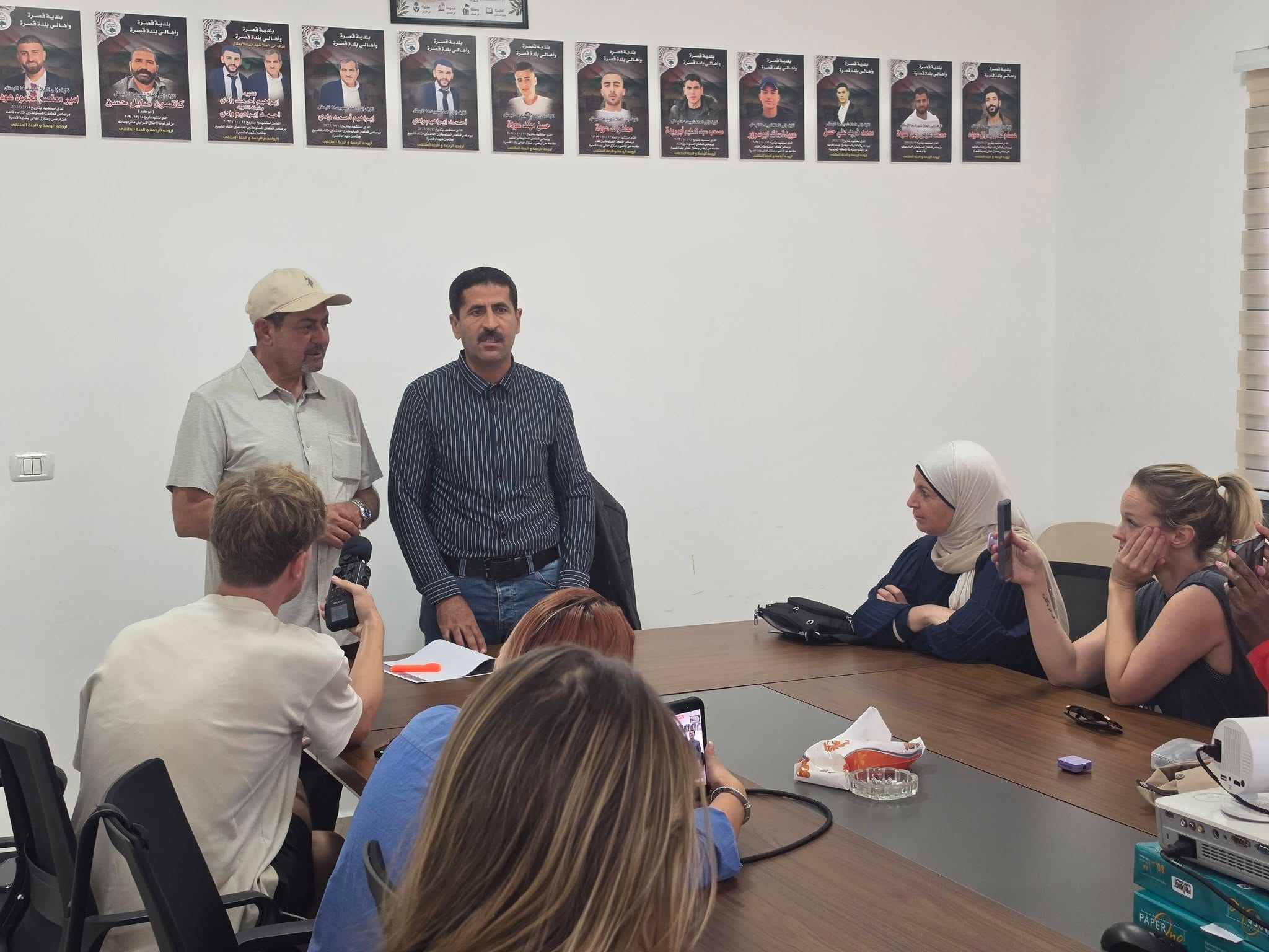
QUSRA, WEST BANK, PALESTINE — In the back room of an otherwise plain and colorless municipal building, the names and photos of twelve young men murdered by Israeli military and settler terrorists looked down on us as we arrived.
The memorials were hung over the meeting space as a reminder of the increasing violence against Palestinians, and of the freedom that has become an artifact of the past.
Palestinian Muslim families have been living in Qusra since at least the 1500’s. In the 1882 Survey of Western Palestine, Qusra was described a small village low in the valley, a few hundred inhabitants, with large olive and oak trees.
The 1922 Census of Palestine showed 707 people in Qusra; by 1931, 851 people; and in 1961, the Jordanian survey counted 1,312 people.
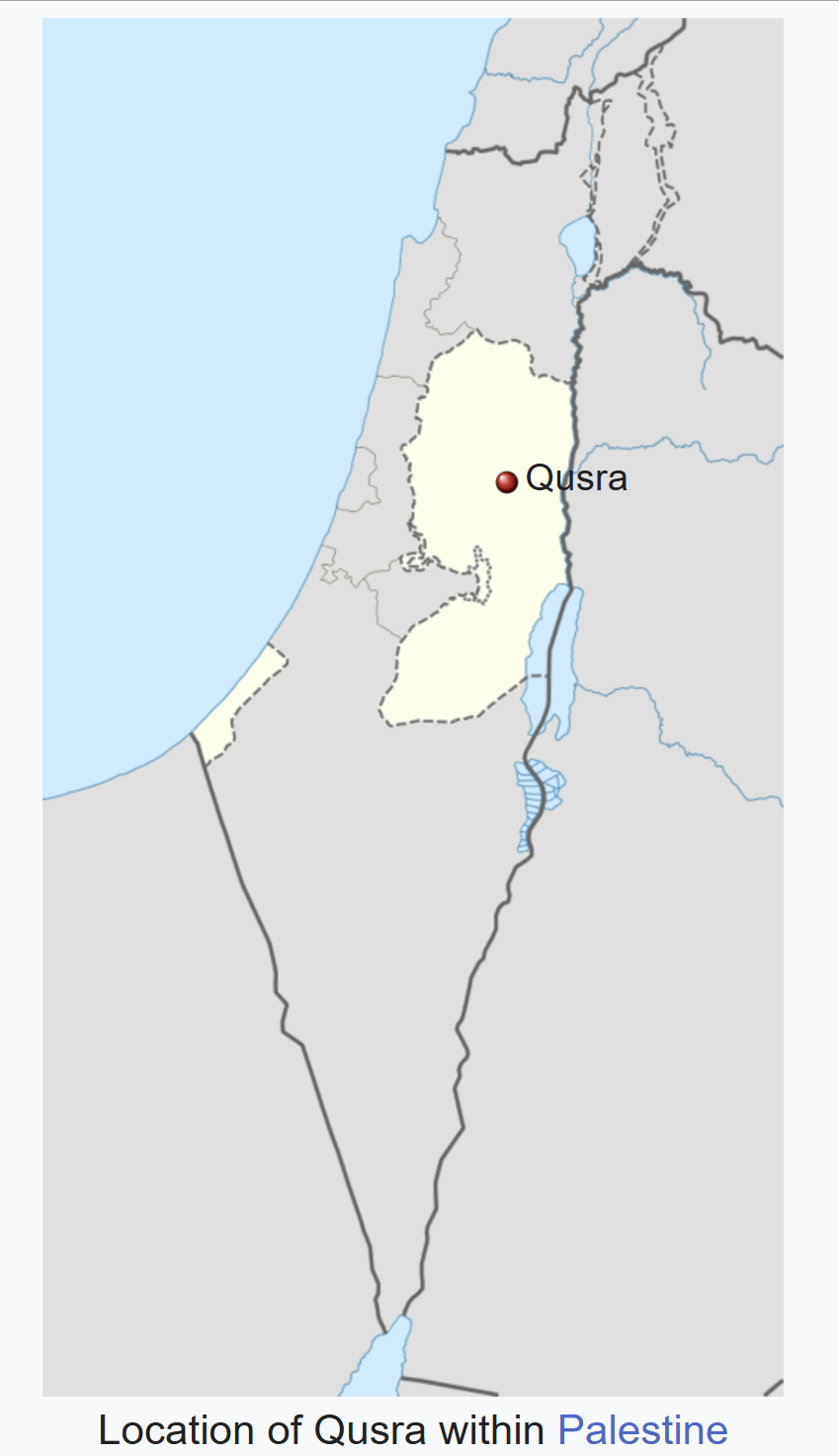
During the 19 years of Jordanian rule, Qusra flourished. Then Israel began illegally occupying the West Bank in 1967, and families began living under siege.
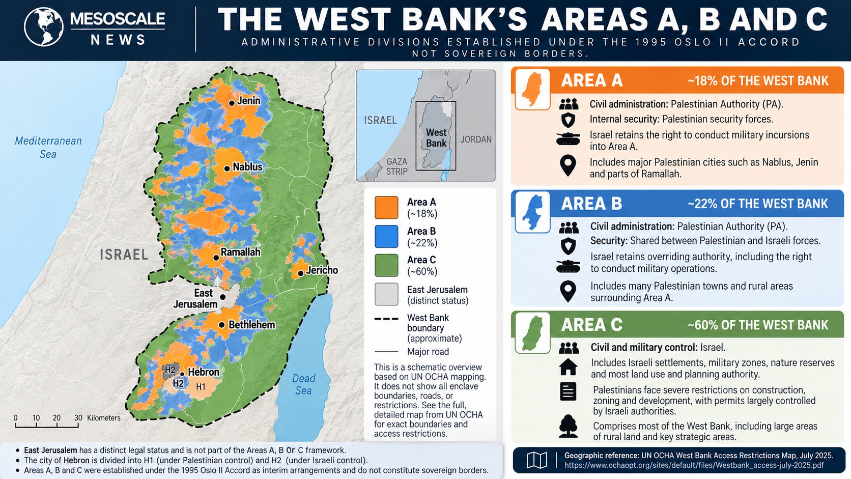
Then in 1995, the Oslo II Accords took the 2,500 acres of Palestinian land in Qusra and cut it in half — 50% would be in Area B and 50% in Area C.
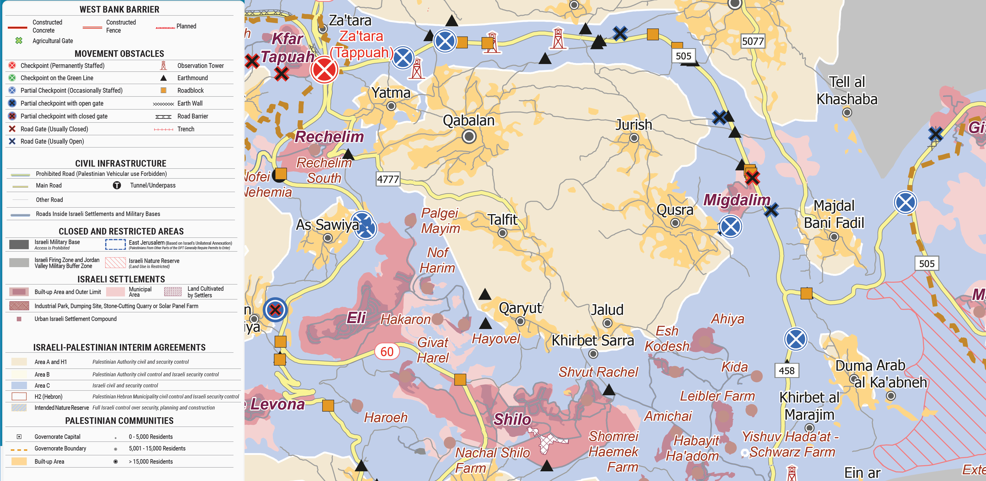
Israeli stole another 50 acres to build the illegal settlement of Migdalim.
Migdalim, like most illegal Israeli settlements and outposts, was built on Palestinian agricultural lands — mostly olive groves and orchards.
By 2010, 50 homes had been built on the area. Today, Migdalim has a population of more than 800 people.
Earlier this year, Israel approved an expansion of 140 new homes for the illegal settlement.
Settlements like Migdalim surround Qusra today, isolating it from neighboring villages, putting them under constant surveillance, the theft of land creeping closer and closer every day.
Palestinian communities have become islands in a sea of bureaucratic violence, surrounded by sharks, never knowing if they’re safe from an incursion.
Qusra Mayor Abed Wadi recalled how there had once been olive trees and fig trees, weddings, children playing in the streets in the areas around the city. There were farmers who knew the surrounding hillsides not as disputed territory but as the land their families had cultivated for generations. There had been the ordinary pleasures of belonging somewhere, the unremarkable certainty that a person could leave home in the morning, work his fields, and return in the evening.
When our American delegation arrived in Qusra in September 2026, Wadi asked us to imagine visiting nearly twenty years earlier.
“If you had come to visit the town before 2008 and 2009, I would have explained and introduced Qusra in a different way than what I’m doing today, because the circumstances were totally different.”
He had prepared a different history for us now. It was a history of burned homes, destroyed olive groves, roads closed by the Israeli military, and relatives who had been killed.
Four of the young men, Hasan Abu Sorour, 16, Obayda Abu Sorour, 17, Moath Odeh, 21, and Musab Abu Reda, 25, were killed when a mob of Israeli settler terrorists began attacking family homes in Qusra on October 11, 2023.
As the funeral procession gathered the next day, Israeli settler terrorists open fired on the vehicles, killing two Palestinians.
The dead were Wadi’s brother, Ibrahim, 63, who was a senior official in the Palestinian Ministry of Finance, and his brother’s son, Ahmed, 26, who recently graduated law school and became engaged.
Wadi described the killings with the familiarity of someone who had repeated these details too many times, and with the grief of someone for whom repetition had made them no easier.
His account was also a geography lesson.
The destruction of Qusra is not measured only in the number of Palestinians killed, the homes attacked, or the olive trees destroyed. It is measured in the shrinking territory residents can safely occupy, the farmland they can no longer cultivate, the roads they can no longer travel, and the distances between communities that grow longer without the towns themselves moving an inch.
In Qusra, Palestinians are not simply losing land. They are being systematically separated from the means of living on it.
The process is sometimes described in the language of settlement expansion, as though the principal development were the construction of houses. The people we interviewed used considerably less forgiving language. They described armed Israeli terrorists, intimidation, dispossession, and the deliberate destruction of Palestinian life.
Their testimony, supported by years of human rights investigations and United Nations reporting, reveals a system in which violence does not merely accompany territorial expansion.
Violence is how the expansion happens.
The village remains on the map — for now. The world around it is being taken away.
A village measured in funerals
Wadi traced the transformation of Qusra to the years surrounding 2011, when armed Israelis attacked agricultural property and burned a mosque. He described thousands of olive trees damaged or destroyed, farming equipment confiscated, and residents increasingly prevented from reaching their fields.
“They confiscated farming equipment. They confiscated tractors, bulldozers. They prevented us from accessing or farming. We started going to our own olive fields and olive trees as strangers.”
International calls for accountability and justice went unanswered, and the violence continued to escalate.
For a farming community, land is not merely property. It is memory made physical. Families inherit trees planted by parents and grandparents, terraces maintained across generations, and an intimate understanding of soil, rainfall, seasonal rhythms, and harvests. The landscape holds knowledge that cannot be transferred to another place.
To be denied access to it is to lose something long before the property records change.
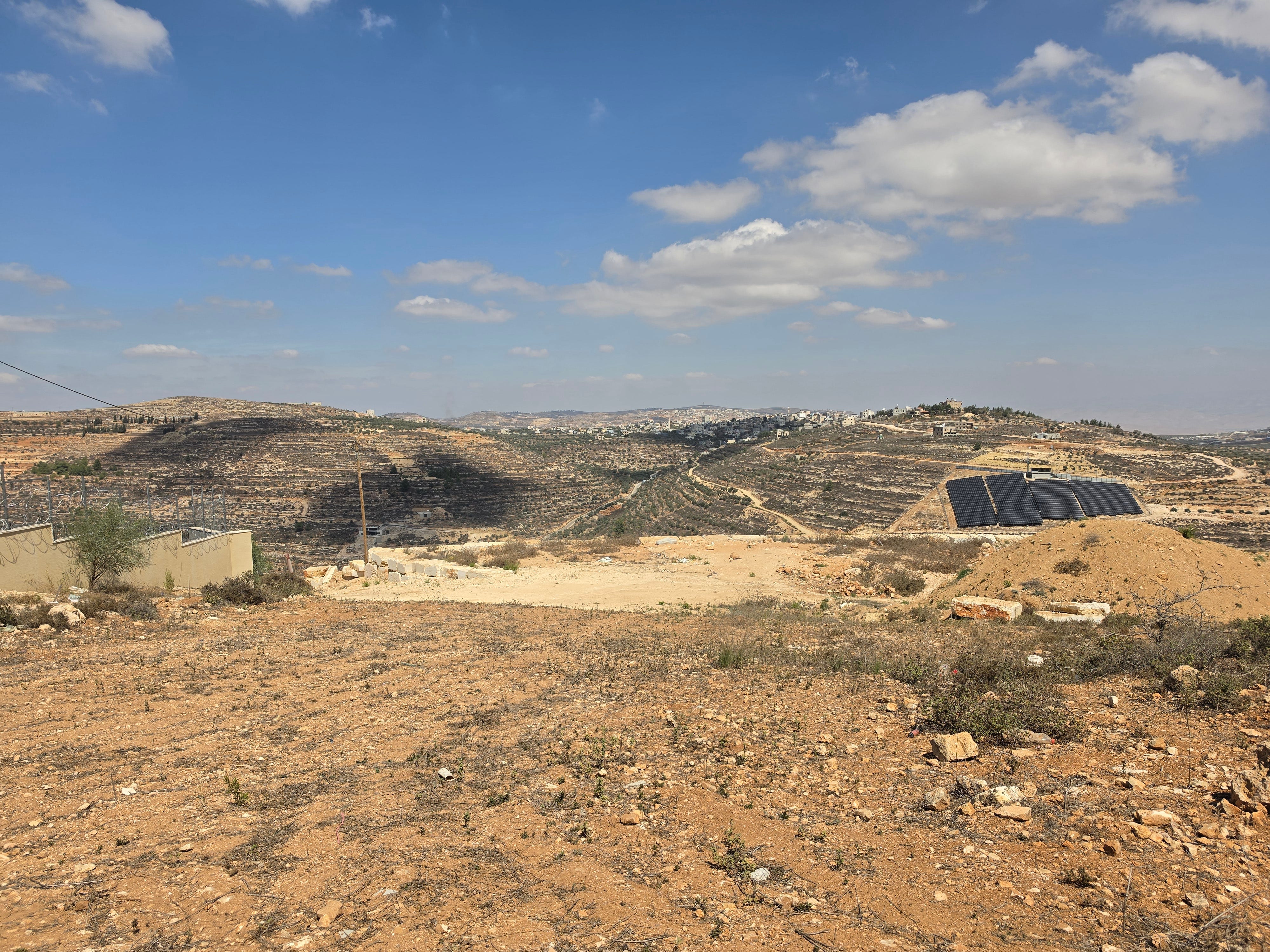
The killings came in succession. The mayor recounted deaths across multiple years, including the October 2023 attacks that devastated Qusra.
“It was the darkest day for Qusra. Because the settlers killed six young men on that same day together.”
A January 2024 investigation by The Washington Post reconstructed the attacks through witness accounts, video evidence, and other documentation. Its headline captured one of the investigation’s central findings: “Settlers killed a Palestinian teen. Israeli forces didn’t stop it.”
The investigation also reproduced a threat sent to Qusra residents before the attack. The message addressed Palestinians as animals and promised that revenge was coming.
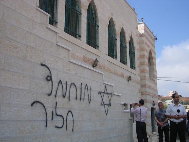
What followed was not an unforeseeable eruption of anger. Residents had been threatened, armed attackers arrived, and Palestinian families were left to confront the consequences.
For the mayor, the losses were personal.
“One of whom was my brother, my own brother”
His brother Ibrahim, he explained, had eleven children. A younger family member, twenty-four years old and studying law, was engaged to be married.
It is easy for the scale of Palestinian suffering to become obscured by numbers. Here, each number had a family attached to it: eleven children, a wedding that would never take place, an empty place at the table.
The attacks continued.
On April 13, 2024, roughly 180 to 200 armed Israelis descended on Qusra, burning agricultural buildings, homes, vehicles, and municipal property. Wadi described livestock killed and residents injured.
“They burned houses that was already inhabited and houses that were under construction. They burned cars. They killed cows and sheep.”
Then he added:
“And one of the injured was one of my own children.”
In August 2026, weeks before our visit, armed Israelis again attacked homes in Qusra.
Reuters reported that dozens of masked attackers threw stones at a house while seven Palestinians were trapped inside. According to witnesses, Israeli forces subsequently fired tear gas into the home and detained its Palestinian occupants. The residents described being blindfolded, handcuffed, and beaten.
The violence had moved from the agricultural hillsides to the thresholds of people’s homes.
The small outpost and the enormous territory it controls
Driving toward Qusra, we passed Israeli settlements extending across the hilltops. Our Palestinian guide identified Shilo, Eli, and Ma’ale Levona, pointing toward agricultural land that Palestinian communities could no longer freely access.
Geography is not only about what occupies a place. It is also about who has been excluded from it.
Our guide pointed toward land associated with nearby Palestinian communities.
“They’ve taken over the land.”
Later, explaining the restrictions on movement, he told us:
“We’re only using this road because it’s the only road connecting between north and south.”
Palestinians could travel along the route, he explained, but entering the surrounding settlement areas was prohibited or dangerous.
The road had become a narrow corridor through a landscape over which others exercised control.
During our meeting in Qusra, a delegation member asked about the groups establishing themselves around Palestinian villages. Were these isolated attackers, or was there a larger structure behind the intimidation?
The municipal representative rejected the language of isolated misconduct.
“First of all, I consider the the settlers, who Netanyahu calls outlaws, rioters, we call them terrorists.”
The people burning homes, attacking farmers, and driving families from their land were not simply unruly neighbors. They were participating in a territorial campaign of terrorism and murder.
He described armed groups supplied with vehicles, weapons, and equipment, establishing themselves near Palestinian agricultural land and extending their influence through intimidation.
The result, he said, was the seizure of territory without the cost or visibility of a conventional military operation.
This is the fundamental geography of the Israeli outpost system.
A small number of structures can occupy a ridge while the armed men living there exercise control over an area many times larger. A Palestinian farmer may still possess a deed to the surrounding land, but that document offers little protection against someone waiting with a rifle.
Israeli organization Peace Now documented the proliferation of outposts in Area B in 2026, demonstrating that the expansion was no longer confined to land already under full Israeli civil administration. Its investigation described the establishment of outposts in territory formally assigned Palestinian civil authority.
The spatial consequences are enormous.
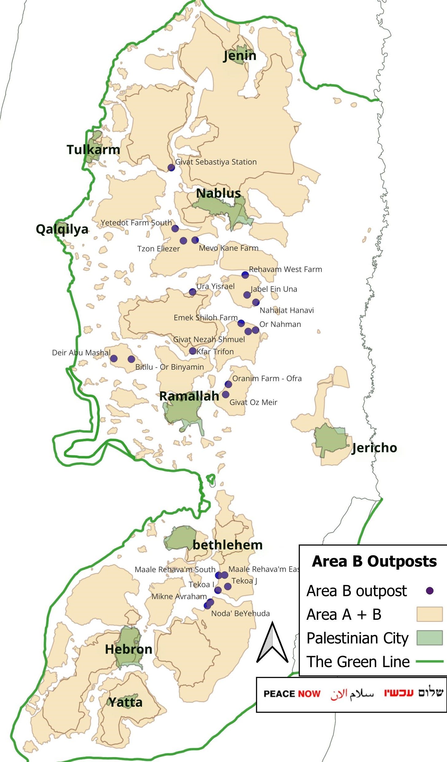
An outpost need not occupy an entire hillside to make the hillside inaccessible. It need only make the consequences of entering sufficiently frightening.
Once Palestinian farmers stop returning, the land becomes available for further encroachment.
What looks on a map like a small point of occupation becomes, in practice, a much larger zone of exclusion.
Land theft without paperwork
A Palestinian representative from Turmus Ayya, whom we interviewed during the same trip, offered perhaps the clearest explanation of how this process works.
He described olive groves that families still owned but could no longer safely enter.
“There’s no such thing as formally seized because they do not give you a notice. They do not tell you that this land has been seized.”
He called it:
“de facto seizure by the conduct of the settlers.”
There is no necessary announcement, no document handed to the owner, no single moment at which the land officially changes hands.
Instead, the farmer learns where he can no longer go.
“You learn it. You become to learn it that this is a dangerous area. I I should not go there.”
This is an especially effective form of coercive territorial control because it requires relatively little continuous enforcement. Once people have been attacked, or have watched their neighbors attacked, the threat becomes embedded in their understanding of the landscape.
The boundary is no longer simply a fence or checkpoint.
It is fear.
The farmer knows which road may be blocked, which grove may be watched, which hillside may conceal armed men. He adjusts his movements accordingly. His children learn the same geography.
Eventually, the prohibited territory becomes abandoned: a place everyone knows belongs to the village, and everyone knows they must avoid.
In geographic terms, legal ownership remains intact while practical access collapses.
The occupation creates two overlapping maps: one of property and another of power.
The second increasingly determines whether the first means anything.
When the army arrives
Another representative from Turmus Ayya also described how armed Israelis exploit military authority to remove Palestinians from their own land.
He said attackers often approach in groups, with weapons displayed openly. They push or provoke Palestinian landowners while recording the confrontation on their phones.
“They start pushing me, kicking me, you know, shouldering me, pushing me with their hands and with their phones.”
Then, he explained:
“When I raise my hand, they call the IDF and claim that I attack them.”
Israeli soldiers then intervene against the Palestinian.
“So they come and detain me and arrest me and take me somewhere so I can disappear for a week or two.”
He described being detained for four hours with his wife and a news crew and said the crew was instructed to erase its footage before being released.
In October 2025, the United Nations Office for the Coordination of Humanitarian Affairs confirmed that armed Israelis, accompanied by Israeli forces, had prevented Palestinian farmers from reaching olive groves across several West Bank communities.
In nearby Kobar, residents were reportedly required to seek permission from an outpost guard to access agricultural land that had previously been freely accessible. Elsewhere, armed Israelis seized harvested olives while farmers were prevented from working their land.
This is a profound inversion of territorial authority.
The Palestinian farmer becomes the person required to explain why he is present.
The armed Israeli occupying or controlling the surrounding land becomes the person deciding whether he may stay.
In Qusra, residents described the same inversion at their homes. The August 2026 Reuters investigation documented allegations that Israeli forces detained Palestinians after armed Israelis attacked the house in which they had sought refuge.
A system that repeatedly exposes Palestinian landowners to violence, detention, and exclusion while enabling armed groups to maintain territorial control cannot be understood simply through the language of sporadic criminality.
Its effects are geographic, cumulative, and political.
The olive harvest, interrupted
The most revealing measure of Qusra’s dispossession may be found not in a military map but in the village’s olive oil production.
A Qusra official reported that Qusra produced approximately 123 metric tons of olive oil in 2023, falling to 115 in 2024 and just 58 in 2025. For 2026, he anticipated only 16 to 20 metric tons.
Qusra’s disappearing olive harvest
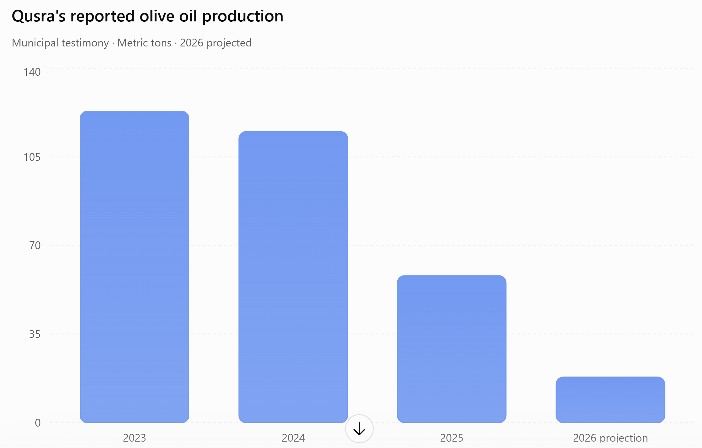
If the projection holds, production will have fallen approximately 85% from its reported 2023 level.
Olive trees naturally experience fluctuations in productivity. Rainfall, temperature, disease, and alternate-bearing cycles influence harvests. These figures alone cannot isolate the effects of violence from environmental variability.
The interviews explain how farmers are being prevented from carrying out even the most basic agricultural work.
Another official from Turmus Ayya described three essential periods of access: preparing the soil in February, clearing vegetation around the trees in August, and harvesting the olives in October and November.
“But the biggest attacks occur during harvest itself, because there’s a time limit in in which you can harvest.”
The timing matters. Olives cannot simply wait indefinitely for armed men to leave. Harvesting too late reduces quality and can destroy a season’s economic value.
For farmers already operating with narrow margins, missing the harvest may mean losing an entire year’s income.
He described how his household had once produced enough olive oil to give away to relatives and friends. Now, he said:
“Right now, we buy our own. We have to go out and buy it.”
A family that once cultivated, pressed, consumed, and shared its own olive oil had become dependent on purchasing it.
This is what agricultural dispossession looks like inside a household.
Across the West Bank, the scale of the destruction is staggering.
OCHA documented 1,680 Israeli attacks resulting in casualties or property damage across more than 270 communities during 2025. During October and November alone, the agency recorded 178 attacks associated with the olive harvest across 88 communities. More than 6,000 trees and saplings were vandalized that year.
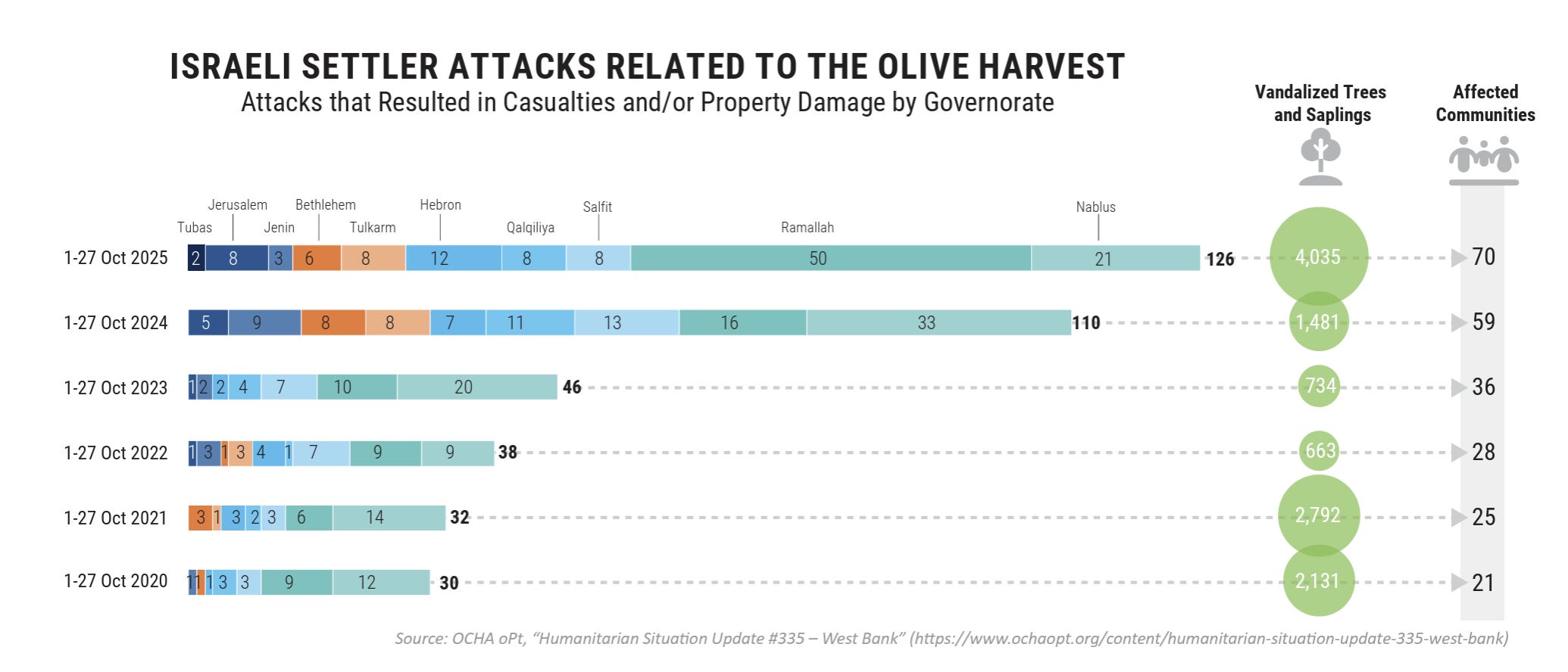
These figures do not capture every farmer who stayed home out of fear, every field that went untended, or every family that lost access to land without an incident recorded by international monitors.
The ecological consequences may also outlast the immediate violence. Agricultural terraces require maintenance. Soil needs protection against erosion. Trees require pruning and care. Traditional agricultural systems are sustained by repeated human labor across generations.
Denying farmers access to their land damages the relationship between people and the environment that makes cultivation possible.
An olive tree may survive the attack. The agricultural system surrounding it may not.
The disappearance of Area B
Qusra’s representatives described an increasingly aggressive expansion of armed Israeli activity from Area C into Area B, where Palestinians are formally assigned civil administrative authority under the Oslo framework.
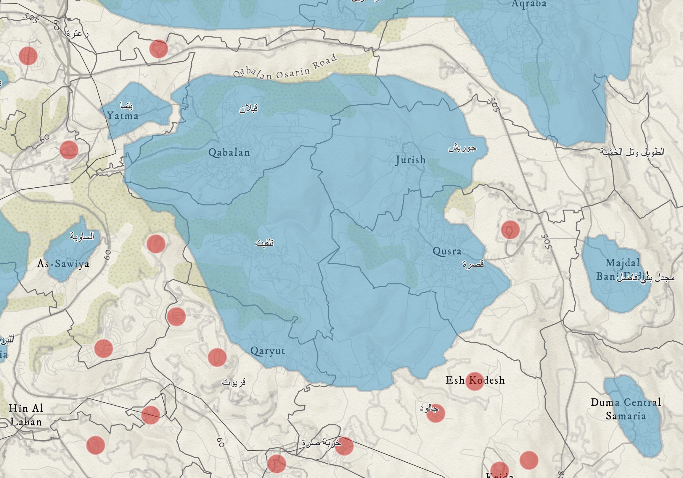
“ The violence and the intimidation have reached houses that fall in area B.”
Wadi described three families living in houses that had become effectively separated from the rest of the village.
Armed Israelis, he said, had established tents near their homes, obstructed access roads, and interfered with essential services.
“Electricity and water has been cut to some of the residents.”
The families included young children.
The municipality could no longer reliably reach them with supplies.
“It prevented us as a municipality and as a town from getting their needs of electricity, water, food, and supplies.”
This is more than land encroachment. It is the isolation of Palestinian families within their own community.
The distinction between Areas A, B, and C was intended to define different administrative arrangements within an already illegal occupation. Yet the expansion of armed outposts and intimidation across those boundaries reveals how little protection such divisions provide when control over movement and security is exercised unequally.
A family may live within an area designated for Palestinian civil administration and still be unable to receive water, electricity, or food from its own municipality.
The boundary exists in law. It is disregarded in practice.
The road that takes hours
The geography of dispossession extends beyond farmland.
Wadi described the closure of the village’s main entrance since October 2023. The journey to Nablus, once approximately twenty minutes, could now take hours.
“The passenger fare to get to Nablus used to be 8shekels. Now it’s 22 shekels.”


The cost of a journey had nearly tripled.
The physical distance, of course, had not changed.
This is the distinction between geometric distance and functional accessibility. Two communities may remain separated by only a few kilometers, yet checkpoints, roadblocks, military closures, and detours can make traveling between them exhausting, expensive, or impossible.
The consequences ripple through daily life.
A hospital becomes harder to reach. A farmer loses access to markets. A student spends hours traveling to school. Families become isolated from relatives living in neighboring villages.
Wadi explained that visiting nearby Turmus Ayya could require planning an entire day.
The roads still existed, but their purpose had been transformed.
Rather than connecting Palestinian communities, they had become instruments through which access could be restricted and controlled.
The geography of fear
During our trip, we also interviewed a Palestinian journalist who described being attacked while reporting near Nablus.
In one incident, she said armed Israelis fired live ammunition toward her and a colleague. In another, she was alone in a vehicle when armed men approached from a hillside.
She fled.
“The first thing I did is left the car, and I start running, run and run and start screaming to my colleague to hear me.”
She described how the terror continued long after the immediate danger had passed.
“You don’t discover it in the first days, but you have some trauma because you will dream”
Yet she refused to abandon her work.
“I will never give up.”
Her determination speaks to a broader reality: Palestinians are forced not only to survive the occupation but to document it, often at enormous personal risk.
On October 6, 2026, AFP photographer Jaafar Ashtiyeh was beaten by armed Israelis while covering violence against Palestinian olive farmers near Aqraba. His camera equipment was stolen, and he was hospitalized with injuries. The attack occurred near Israeli soldiers, who, according to witnesses, did not intervene.
The risks facing journalists are part of the same landscape of intimidation confronting farmers and residents.
The violence regulates who may enter a place, who may remain there, and who may record what happens.
Fear becomes a method of territorial governance.
The architecture of dispossession
The processes unfolding around Qusra are consistent with decades of scholarship examining the spatial organization of Israeli occupation.
In Ethnocracy: Land and Identity Politics in Israel/Palestine (2006), geographer Oren Yiftachel analyzes how territorial policies and unequal access to land can reproduce political domination.
Eyal Weizman’s Hollow Land: Israel’s Architecture of Occupation (2007) examines the ways settlements, roads, military installations, and planning systems reorganize Palestinian space.
Both provide important frameworks for understanding why dispossession cannot be measured solely by the number of buildings constructed or acres formally confiscated.
Territorial control is also exercised through mobility, infrastructure, access, and fear.
An armed outpost on a ridge can deny farmers access to surrounding valleys.
A closed gate can separate a village from its regional economy.
A blocked road can prevent a municipality from reaching families who live within its own boundaries.
An attack during olive harvest can destroy a year’s income without damaging a single property deed.
The result is a landscape in which Palestinians may retain formal claims to land while losing the practical ability to inhabit and use it.
The International Court of Justice’s July 2024 advisory opinion found Israel’s continued presence in the occupied Palestinian territory unlawful and addressed the legal consequences of settlement expansion, land appropriation, and discriminatory restrictions on Palestinians. The Court’s opinion placed these territorial practices within the broader framework of international law.
The geography of Qusra reveals how such violations become part of ordinary life.
The occupation is experienced not only through soldiers and weapons, but through the impossibility of reaching a field, the expense of traveling to a nearby town, and the uncertainty of whether a family can safely sleep in its own home.
What remains of Qusra
Toward the end of our meeting, Wadi returned to the contradiction between the language of democracy and human rights, and the conditions his community was enduring.
He had described murdered relatives, destroyed farms, families isolated from their neighbors, and children living under armed intimidation.
He was not asking us to imagine some distant political possibility.
He was describing what it takes for a village to remain alive.
A functioning community requires more than buildings and boundaries. It needs access to water, electricity, agricultural land, schools, hospitals, markets, and the surrounding landscape.
It needs the freedom to move.
It needs the ability to cultivate the soil and harvest what grows from it.
And it needs the reasonable expectation that its residents can return home without being attacked.
Qusra still possesses its name, its history, and its people. Its olive trees still stand on the hillsides. The agricultural terraces remain etched into the landscape.
But those physical remnants conceal the destruction taking place around them.
The land has not moved. The villages have not moved. The distances between them have not changed.
What has changed is who can cross those distances, who can cultivate the fields, and who can live without fear.
That is the geography of dispossession.
It is not only the theft of Palestinian land. It is the deliberate destruction of the relationships between people and place that make a homeland possible.
And in Qusra, the evidence is everywhere: in the groves left unharvested, the roads made impassable, the families trapped in their homes, and the names of the dead recited by a man who once would have welcomed visitors with stories about weddings and olive trees.
Qusra remains on the map for now, but increased violence and land seizures may one day lead to its destruction.
If you want to continue reading this series and/or support my work, please be sure to subscribe!


