
2026 Hurricane Activity Projections Out Today

Independent, data-driven climate reporting like this doesn’t happen without support. If you value clear analysis over hype, and accountability over spin, consider becoming a paid subscriber to keep this work going.
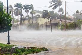
A “Quiet” Hurricane Season
There’s a particular kind of risk that only shows up in the margins in the years when the numbers look reassuring, when forecasters hedge toward “below average,” when the headlines drift elsewhere.
That’s where 2026 is shaping up to live.
Researchers at Colorado State University released one of the first major forecasts for the Atlantic hurricane season:
13 named storms
6 hurricanes
2 major hurricanes
For context, in 2025 we had:
13 named storms
5 hurricanes
4 major hurricanes
After years of hyperactive seasons fueled by record ocean heat, a step down feels like a break in the pattern.
The central driver behind this year’s forecast is the expected development of El Nino in the Pacific.
El Nino tends to increase vertical wind shear across the Atlantic — essentially tearing apart developing storms before they can organize. That’s why forecasters are leaning toward fewer hurricanes overall.
But hurricane seasons don’t unfold neatly according to a single variable.
Even as El Nino suppresses storm formation, other signals are pushing in the opposite direction. Sea surface temperatures in parts of the Atlantic (particularly the western basin) remain anomalously warm, providing fuel for any storm that does manage to form.
This is the paradox of modern hurricane seasons: fewer storms doesn’t necessarily mean weaker ones, and it certainly doesn’t mean safer coastlines.
Between 1991 and 2020, the Atlantic averaged roughly 14 named storms, 7 hurricanes, and 3 major hurricanes per season.
Colorado State’s forecast sits just under that line.
But that baseline itself is already elevated by decades of warming oceans and shifting atmospheric patterns. In other words, a “quiet” modern season would have been considered active a generation ago.
And even within that quieter framework, other forecasts are less restrained.
AccuWeather projects 11–16 named storms, including up to 4 major hurricanes.
The Weather Company similarly expects a near- to below-average season, but still with multiple hurricanes and at least two major storms.
Even in a below-average year, the probability of landfall isn’t zero. Recent analyses put the chance of a hurricane affecting parts of the U.S. coastline this year at levels that remain significant, even if slightly reduced from average.
And history has already made the point more brutally than any model ever could.
1992 was a quiet season — until Hurricane Andrew.
One storm is enough. It always has been.
Seasonal forecasts are built on large-scale signals — ocean temperatures, atmospheric circulation, patterns stretching from the Sahel to the Pacific.
Colorado State’s methodology reflects that complexity, incorporating variables like:
Relative sea surface temperature contrasts
Atlantic Meridional Mode (AMM)
African monsoon dynamics
Saharan dust outbreaks
Each of these influences whether storms form — and how they behave once they do.
This April forecast is just the first pass.
Colorado State will update its outlook in June, July, and August as the atmosphere begins to reveal what it’s actually going to do.
Between now and then, the key signals to watch are:
Whether El Nino fully develops — or stalls
How warm the tropical Atlantic remains relative to the Pacific
Early-season storm formation patterns
The evolution of wind shear across the Caribbean and Gulf