
Was the earthquake in Iran a nuclear bomb?
I spoke to the experts to debunk the online conspiracy

Mesoscale News is reader-supported reporting from a scientist’s perspective — explaining the climate, disasters, and scientific controversies shaping our world without corporate spin or partisan noise.
If you value evidence-based reporting that cuts through viral misinformation, consider becoming a paid subscriber to support this work.
In the hours after a moderate earthquake struck Iran this week, social media filled with confident declarations that the shaking must have been something else entirely: a secret nuclear test or even the detonation of a bomb.


It’s a familiar pattern in the modern information ecosystem. A real scientific event occurs. Data begins to come in. And before scientists have even finished verifying the basics, speculation races ahead of the facts.
To understand what actually happened, I spoke with seismologists Dr. Felix Rodriguez Cardozo and Dr. Jochen Braunmiller of the University of Florida about how scientists distinguish between natural earthquakes and nuclear detonations.
Their answer was straightforward: the physics of the Earth leaves very little ambiguity.
First, it helps to understand just how common earthquakes actually are.
Earthquakes are not rare disruptions of an otherwise stable planet. They are one of the most routine expressions of how our planet releases stress along its tectonic boundaries. According to the U.S. Geological Survey, 49 earthquakes of magnitude 2.5 or greater were recorded worldwide Tuesday.
If you widen the lens to look at an entire week of seismic data, the map begins to look like static — points scattered across plate boundaries, mountain belts, and rift zones. The Earth is always moving, always adjusting, always redistributing energy stored deep in the crust.
And that’s only the earthquakes we bother to catalog in most global summaries.
The USGS typically lists earthquakes 2.5 magnitude and larger in its widely viewed global feeds because anything smaller quickly becomes overwhelming. But instruments detect vastly more seismic activity than that.
Across the United States alone, thousands of small shaking events occur every week. Most are far below the threshold that people can feel. They register only as faint pulses in the sensitive instruments of seismic networks spread across the continent.
If every one of those micro-events were plotted on a map, the Earth would appear almost constantly in motion.
A quick side note for those who learned about earthquakes in older textbooks: scientists no longer use the Richter scale. The modern measurement is the moment magnitude scale (Mw), which more accurately reflects the total energy released during a seismic event, especially for larger earthquakes.
That distinction matters because the details of the seismic signal are exactly how scientists determine what caused the shaking in the first place.
Every seismic event — whether it’s an earthquake, a landslide, a mine collapse, or a nuclear test — produces a distinctive pattern of waves moving through the Earth.
The two most important types of seismic waves are P waves and S waves.
P waves, or primary waves, are compressional. They move through rock the way sound waves move through air, pushing and pulling material in the direction of travel. Because they move fastest, they are the first signals recorded on a seismograph after an event occurs.
S waves, or secondary waves, move differently. Instead of compressing the rock, they shear it side-to-side. They travel more slowly and arrive after the P waves, but they often carry much stronger motion.
The relative strength and timing of these waves reveal a great deal about the source of the shaking.
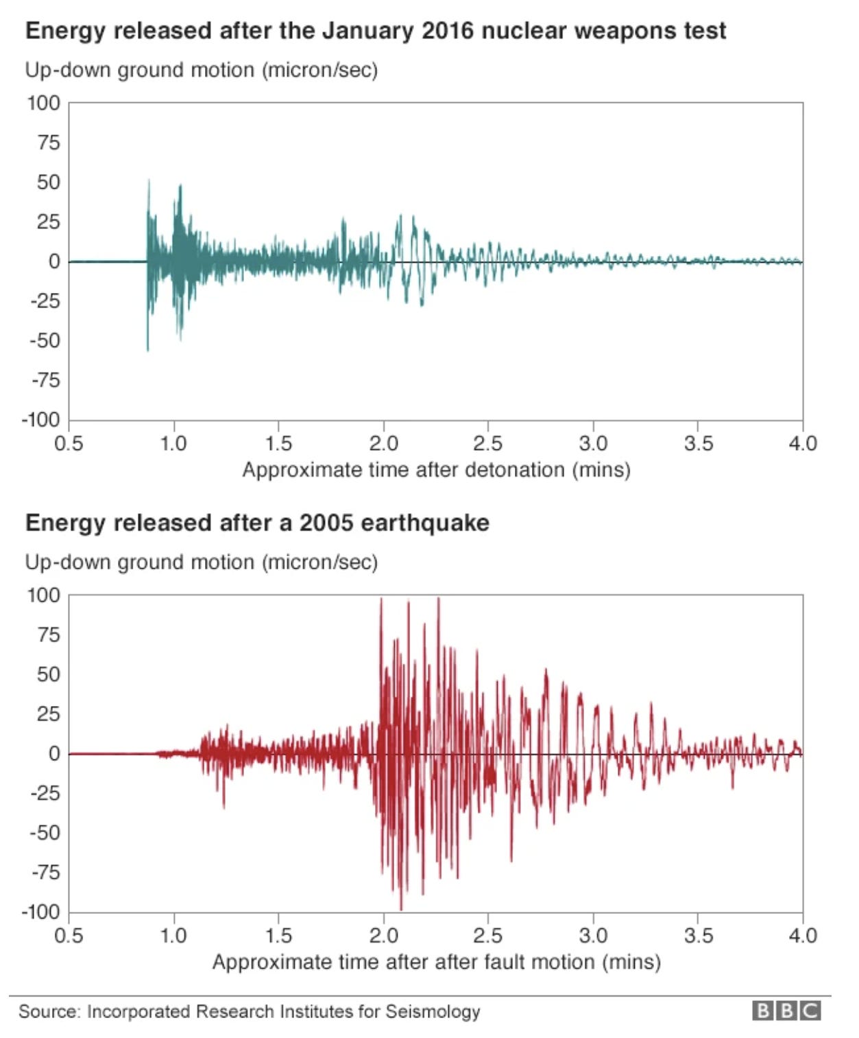
Natural earthquakes occur when stress builds along faults in the Earth’s crust until the rock suddenly slips. That slipping motion generates strong S waves as the crust moves laterally against itself.
Nuclear explosions are fundamentally different. A nuclear detonation releases energy outward in a nearly spherical blast. That kind of source produces a seismic signal dominated by P waves, with comparatively weaker S-wave energy.
Depth also provides a major clue.
Earthquakes occur within the crust along known tectonic structures. The Iranian earthquake this week occurred at a depth of about 10 kilometers, which is entirely consistent with natural tectonic activity in the region.
Nuclear tests, by contrast, are conducted very close to the surface — typically less than one kilometer deep — because the goal is containment of the explosion rather than interaction with tectonic faults.
Those differences are so clear that global monitoring systems designed to enforce the Comprehensive Nuclear-Test-Ban Treaty routinely detect and classify seismic events across the planet. Networks of sensors operated by international agencies analyze waveforms in real time to determine whether a signal originated from an earthquake or an explosion.
According to the seismologists I spoke with, the seismic data from the Iranian event shows the unmistakable characteristics of a natural earthquake.
You can view the presentation they made for me here.
But there is another piece of context often missing from viral speculation: Iran is already a seismically active country.
The nation sits at the collision zone where the Arabian tectonic plate presses northward into the Eurasian plate, gradually building mountain ranges and fault systems across the region. That slow geological squeeze produces frequent earthquakes of varying sizes.
Iran has experienced devastating earthquakes throughout its history, including the 2003 Bam earthquake, which killed more than 26,000 people, and the 2017 Kermanshah earthquake, which caused widespread destruction along the Iran–Iraq border.
In other words, earthquakes there are not anomalies. They are part of the normal tectonic behavior of the region.
When viewed through the lens of actual seismic data, the mystery largely disappears.
The depth is consistent with tectonic activity.
The wave pattern matches a fault rupture.
And the region itself is known for frequent earthquakes.
None of that stops speculation from spreading online, of course. In an era when every seismic event can instantly become a trending topic, scientific literacy often lags behind viral narratives.
But the Earth’s physics is stubbornly consistent.
Seismographs do not care about geopolitics. They record waves traveling through rock — waves that carry the fingerprints of the forces that created them.
And in this case, those fingerprints point clearly to the same process that has been reshaping the planet’s crust for hundreds of millions of years:
An earthquake. Not a bomb.
I appreciate you using the phrase "those who learned about earthquakes in older textbooks" instead of "you stuck-in-the-past old farts" :D
I just went on Wikipedia to find out that the Hanks & Kanamori paper describing the Moment Magnitude Scale was published in 1979 and the USGS implemented its use in their reporting of quakes in 1986.
So I did indeed learn about earthquakes and their measurement from "older textbooks" (much older). We covered plate tectonics in my college Environmental Sciences geology class so long ago that it was still a somewhat controversial idea at the time, and the phrase "continental drift" was still bandied about.
Well done, RJ. Thanks.