
Hurricane Milton is a climate-crisis storm
The role of climate change in making superstorms and my own experiences in Katrina and Florida.

I was 16 years old when the eye of Hurricane Katrina passed by my hometown in coastal Mississippi. The center of her eyewall was 27.82 miles west of my home. The eye at that point — on August 29, 2005 — was about 25 miles wide, putting me and my family in the worst possible location for the worst of the storm’s impacts.
Hurricane Katrina was a rare beast — its double eyewall, record-shattering storm surge, intense low pressure, and the bathymetry of where it hit made it a once-in-a-lifetime storm.
That one storm erased hundreds of years of history along the Mississippi and Louisiana Gulf Coasts. It demonstrated the best and the worst of our institutions — the government, media, and NGO’s.
It reshaped my understanding of the world, and inspired me to seek out answers about how these “perfect storms” form and devastate communities.
Today, after a four-year detour, I’m a climate specialist for the federal government working directly with at-risk communities to prepare for storms in a warmed world.
And I want to make clear to all my readers where the facts stand on climate change and hurricanes, so that you, too, can better inform others.
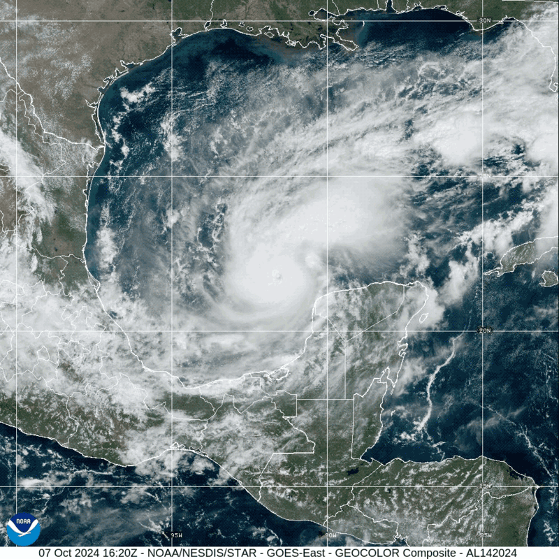
Because Hurricane Milton is a climate-crisis fueled storm.
Forward speed
Hurricanes are moving slower and stalling near shorelines. The slower the rate that storms move across the abnormally warm ocean basins, the bigger and stronger they can become. The slower they move over land, the more rainfall and damage they inflict. Forward speed has decreased by 17% in the Atlantic basin since 1900 (IPCC, Page 1587).
Rapid Intensification
Higher sea surface temperatures and lower salinity increase the amount of moisture available to storms, fueling rapid intensification. But major bursts of thunderstorms far from the storm’s center can also fuel this process, even if overall conditions don’t favor rapid development.
Hurricane Milton rapidly intensified from a Category 1 to Category 5 hurricane in 24 hours, making it the third-fastest acceleration in history, behind only 2005’s Wilma (the strongest hurricane ever recorded) and Felix (2007) in terms of rapid intensification.
Rainfall
Scientists have already observed significant increases in rainfall from hurricanes over the last century. Hurricane Helene, which hit Florida before inundating Appalachia just a few weeks ago, formed in the Gulf of Mexico above record-hot sea surface temperatures (SSTs). Climate change caused a 40-70% increase in rainfall during Hurricane Helene, and has caused a 10-15% increase in rainfall associated with tropical cyclones overall.
Wind speeds
Hurricane windspeeds are, on average, 11% more intense because of global warming. More major hurricane events are occurring compared to prior centuries, as well.
Mean Latitude and Seasonality
One of the clearest and direct impacts of global warming on tropical cyclones is the poleward shift of peak intensity for tropical cyclones. That means as warm waters expand the tropics, tropical storms are migrating northward, too. See my video about Hurricane Kirk here.
With waters generally warmer throughout the year, more hurricanes are appearing outside of historical peak months, extending the season.

Minimum Pressure, Storm Surge
While we classify hurricanes based solely on maximum sustained winds, minimum central pressure better fits models and observations of total storm damage. And although central pressure and wind speed are closely related, they are not identical, and central pressure is widely regarded as the more reliable measure of storm strength.
Research from LSU shows that minimum central pressure 48-72 hours before landfall is the best measure for estimating storm surge. Hurricane Katrina (2005), for example, set the record for hurricane storm surge at 28 feet in south Mississippi. While wind speeds at landfall were measured at Category 3 strength1, the storm’s minimum pressure bottomed out at 902 mbar — making it third strongest hurricane by central pressure to ever make landfall in the United States (behind only 1969s’s Camille and the 1935 Labor Day Storm).
Milton became the fifth-strongest Atlantic Basin hurricane on record Monday, October 7, 2024, reaching a minimum pressure of 897 millibars — about 54 hours before expected landfall. While surge is driven by a multitude of factors, including track, bathymetry, forward speed, etc., this does not bode well from an area of Florida that’s previous peak storm tide2 was 10 feet back in 1921. Worse still, Milton will make landfall during high-tide, adding 2.4 feet of water to the total storm tide level.
The previous record storm surge for the Tampa area — 7.8 ft — was broken two weeks ago when Helene struck Florida.
Sea level rise.
Global sea levels have risen about 9 inches since 1880, and 4 inches just since 1993, and are expected to rise up to 10 feet more by the end of the century. In the Tampa Bay area, sea levels are rising at a faster rate (5.8 mm/yr) than the global average (3.4 mm/yr).

