Category 5 Hurricane Melissa makes landfall in Jamaica
Records smashed in first-ever Category 5 to hit the island
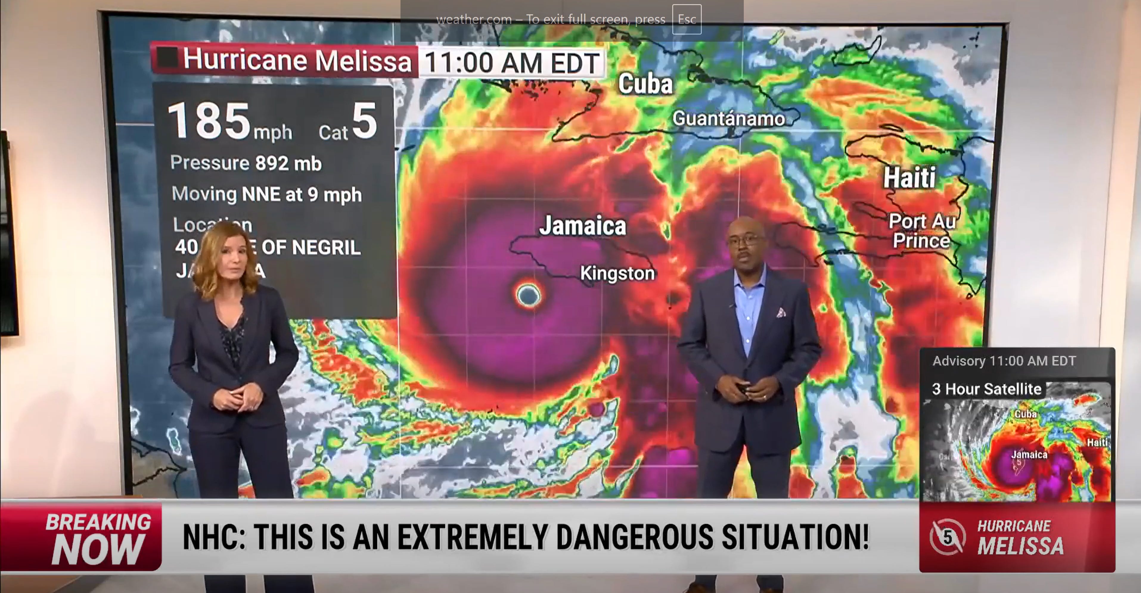
Hurricane Melissa is making a historic, catastrophic Category 5 landfall in Jamaica today with life-threatening flash flooding, landslides, destructive winds, and storm surge in one of the strongest landfalls on record anywhere in the Atlantic Basin.
In the 174 years of recorded hurricane history — dating back to 1851 — Jamaica has never taken a direct hit from a Category 5 storm.
Only two Category 3 or 4 hurricanes have come within close distance to Jamaica — Hurricane Allen (1980) and Hurricane Ivan (2004), both of which were Category 4 storms at the time.
Even Hurricane Ivan, which in 2004 tore along its southern coast as a Category 4, spared the island’s heart.
Melissa has changed that.
She crosses the length of Jamaica today, eye to coast, a perfect diagonal scar across the island’s middle — a Category 5 storm who will reshape Jamaica for decades to come.
With sustained winds of 185 mph and gusts topping 220 mph, Melissa has already rewritten the record books.
Hurricane Allen (1980) holds the record for highest maximum sustained winds in history for the Atlantic basin at 190 mph, just 5 mph more than Melissa.
Allen’s peak wind gust recorded on land was 130 miles per hour.
However, a 241 mph gust recorded near Hurricane Melissa’s eye wall this morning is now the strongest ever measured in the Atlantic basin.
Even worse — the storm’s forward velocity (how fast the storm itself moves across the earth) is an incredibly slow 3 mph.
For context, Katrina caused the damage it did to the Gulf Coast moving 12-15 mph. Ivan moved through the Caribbean at about 12 mph. Hurricane Allen — with the highest maximum wind speeds on record — moved through the Caribbean at 25 mph.
This was not unforeseen.
Earlier in the year, forecasters warned that the 2025 hurricane season could be among the most extreme in modern history — a “hyperactive” year fueled by record-breaking ocean heat, low wind shear, and a persistent El Niño-La Niña transition.
The Atlantic’s sea surface temperatures this summer averaged 2 to 3°C above normal — warm enough to supercharge storms like Melissa into monsters that defy historical precedent.
What we’re witnessing is not just meteorology — it’s physics and consequence.
A hotter planet stores more energy, and that energy now spins through our atmosphere, tearing across coastlines that never used to see storms like this. Climate change has turned the Caribbean into a crucible of extremes, where every new hurricane season is not a cycle, but an escalation.
And this storm does not stand alone.
The same heat fueling Melissa is bleaching coral reefs from Belize to Fiji, melting Antarctic ice at a pace once thought impossible, and driving marine die-offs from the Gulf of Maine to the Galápagos.
The entire global system is connected — one ocean, one atmosphere, one shared fate. What happens in the Caribbean does not stay there; it reverberates outward, reshaping coastlines, economies, and lives everywhere.
The physics of warming cannot be negotiated — and storms like Melissa are its most unflinching messengers.


